Spending Time in the Mountains Near Denver
I have a friend that lives in El Paso, Texas. For the last several years we would visit each other. Justin would come to Montana to go on some adventures, and I would go down there to go on adventures, most consisting of hiking, climbing, boating, fishing, and overall getting outside (perhaps in the future we can tackle some of the top 50 long distance hiking trails). But it turns out there is only so much that you can do near us, and after 8 years or so we started running out of things to do (that don’t involve an extensive drive). We decided to meet in the middle, and explore around Denver, Colorado.

Neither of us had been to Denver (aside from passing through), so it seemed like a great opportunity to explore an area of the country that a lot of people love. If you’re into mountain adventures, then here is my advice on things to do near Denver.
Want to Skip to a Section? Click on it Below:
|
|
The First Struggle: Determining Where to Go
The struggle wasn’t actually determining where to go. It was more of determining where NOT to go. In a city of over half a million people (over 3 million in the metro area) there are a ton of things to do and to see. The result is that you’re bombarded with options, every one of them looks appealing, and you’re left wondering which to cut out.
Fortunately I have friends that grew up in the area, and I was able to get some advice. First order of business was determining where to go near Denver. We decided that Frisco and Breckenridge would be good starting points, and after consulting with friends we determined that a hike to a small lake and tackling some 14ers was in order. Next order of business was to figure out what to do in downtown shortly after arriving. In the end we had to pick an area and just walk around to see what there was.
Driving from Billings to Denver
Plane tickets from Billings to Denver are generally rather outrageously priced ($400+ per person, and when the whole family is going, it gets a little spendy). Fortunately it’s only about a 9 hour drive from Billings to Loveland (where we have friends and a place to stay). And driving allowed us to have a vehicle (no rental needed) to get into the mountains.

While going through Wyoming, from Billings to Denver, you pass through Cheyenne just before getting into Colorado. We don’t have a Chick-fil-a in Billings, and friends rave about the place all the time. So we stopped to see what the fuss was about. Let’s just say it was only that, fuss. Nothing spectacular, nothing amazing, just a simple chicken sandwich. Can someone convince me otherwise? Because I wasn’t feeling it.

Maintaining Sanity with E-470
After getting to the area we unloaded at a friend’s house in Loveland. It turned out to be very fortuitous because they were able to give us advice on how to get around. For instance, I was advised to download the Waze app to help navigate traffic. And I was advised that while I could take the back way to the airport, I should just suck it up and take E-470, the toll road, to avoid a lot of headaches with traffic.
That advice was great. There was almost no traffic, and it turned out to be just $17.75 for 3 trips on the road (1 to pick Justin up from the airport, 1 to drop him off at the airport, and 1 to drive back to Loveland; the missing trip we went right into Denver instead of taking the toll road). The license plate reader sent me a bill in the mail a couple months after the trip. If all tolls could be like this, that would be great.
An Afternoon in Downtown Denver
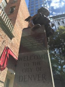 Our main goal was to explore the mountains. But there is so much in Denver, including a bazillion fantastic breweries, that we wanted to explore around there at least a little bit. So we headed to the 16th Street Mall area and started our adventures there.
Parking was no problem, there are spots all over the place and there are lots that cost $8 for an afternoon. We picked one that was sort of central, and then we then hoofed it over to Wynkoop Brewery.

With great food and a big list of beers, it was almost a shame to ever have to leave. But a burger and a pint later (more would have ensued, but driving to Breckenridge after more than a pint would be not good). On our way out we gave knuckles to knuckles the gorilla.
 There were a few hours left to spend in downtown Denver, and we wanted to take in some of the sites. We walked down to the Union Station to admire the architecture. This amazing structure was once a major transportation hub, and now it houses a variety of boutique style shops and small restaurants.

From there we walked around gazing at the buildings, took in the street art near the 16th street mall, found some little alcoves of hidden treasures, viewed the capital building (from afar), saw some pretty cool art, and eventually got tired of walking. It was earlier in the day that we had originally planned, but we decided to head to Breckenridge to eat dinner instead of trying to find our way in the dark.


Driving I-70 to Breckenridge
Coming from Montana, I am used to a good old mountain drive. Passing through switchbacks, crossing mountain streams, and being enveloped by trees on either side is completely normal. What isn’t completely normal is sharing the road with thousands of other motorists all vying for a lane and trying to escape the hustle of the big city.
 Fortunately, the drive to Breckenridge was uneventful. We exited the interstate in Frisco, and took the 9 miles or so back into the quaint little mountain town of Breckenridge. If you have never been there, it’s exactly what you would expect from a Colorado ski town.
Our first stop was at the Mountain River Lodge. Before the trip I scoured the internet trying to find the best deal on lodging. We could have stayed in Frisco for a little bit cheaper, but there didn’t seem to be much as far as night life (not that we are much of night owls. Both Justin and I have small children and being in our early 30’s we are more interested in getting up early than staying up late).
The staff was friendly. They answered our questions of where to go and what to see. And it was nice to be able to spend our first night in the mountains in a warm hotel room rather than in a cold and stuffy tent.

When you have limited time in an area, your biggest problem is deciding exactly what to do. Fortunately we didn’t have to plan any major events on the fly, those were planned out well in advance. What wasn’t planned, however, was where to eat and what to see in Breckenridge. It turns out when you have a town that has a dozen restaurants every block, you can get a little bit of paralysis when determining where to stop.
 We passed by the welcome center, dozens of restaurants, some quaint little stores, and finally settled on the Flatbread Pizza Company. They had outdoor seating with a sweet view, beer on tap, and some of the best flatbread pizza I’ve ever tasted. If you’re in Breckenridge, and you’re in the mood for pizza, then you definitely need to hit up this place.

Adventure Number One: Hiking to Mohawk Lake
 When you’re trying to determine what to do in the Colorado Mountains, you will first notice that there is a lot to do in the Colorado Mountains. There are dozens of little lakes, tons of hiking trails, and depending on how much you want to spend there are plenty of guided tours as well. When planning the trip we had one big goal: to hike a 14er. But we also knew we should acclimate a little bit, so we found this website about hikes near Breckenridge, and chose one of the moderate ones: a hike to Mohawk Lake.
We rolled out just a little before 6AM. Our goal was to get our hike in and be back to the car before any afternoon thunderstorms rolled in. When we got out of the car, we noticed frost on the ground despite the fact that it was early August and over 90 degrees back in Denver. That’s what happens when you’re at 10,000+ feet. We also had to start our hike a bit further down the road than expected, because things got a little western and I didn’t want to wreck up the car.
All in all, it was a gorgeous hike up to Mohawk Lake. The road took us up a steady incline that wasn’t too hard. Once on the trail, it was a fairly simple hike with some great views of the valley below. One of the best parts was that starting our trek at 6:30 or so we had the trail mostly to ourselves.

There are actually two Mohawk Lakes. Lower Mohawk is almost just a wide spot in the creek. Still a fun little area, but not our final destination. You follow the creek up a few hundred more feet, and you crest the hill. The first thing you notice is that you’re eye level with upper Mohawk Lake. It’s almost as though you’re staring down the edge of an infinity pool at over 12,000 feet above sea level.

 The lake isn’t very big, and you can easily walk all the way around it. The water is crystal clear and when you get up high you can see where the bottom drops out and nothing but inky blackness is below. You can also see fish meandering along the banks. We pulled out our rods, and tried a variety of different lures and baits. In the end, just one fish was caught that morning.

We walked around the lake, and fished along the way. We continued to look back at where the trail crests the hill and each time we saw more and more people coming up. By the time we had gone completely around the lake, there were dozens of people and still more coming up the trail. I thought, “This is the most people I have ever seen in the backcountry before.” But with a city of over 1 million less than 2 hours away, it’s bound to be a popular place.

We hiked down early in the day so we could avoid those thunderstorms. Storms that never actually came. It was a sunny and clear day the entire time; a perfect day in the Colorado Mountains. And a perfect day to head back into Breckenridge and enjoy a cold one at the Breckenridge Brewery.

A Night at Kite Lake
When getting beta for our hikes, and when gazing at the maps, it looked as though the drive to Kite Lake, about 45 minutes on the other side of Hoosier Pass from Breckenridge, would be a rough ride. The drive was pretty rough, but not quite as bad as imagined. We left early so we could gauge the road, and see if we could find a nice camping spot.

What ended up happening was we got to the Kite Lake Campground, and we didn’t want to get back in the car and drive down the road. There were about 10 groups already in the campground, and we just decided to pay the $7 and set up camp at 12,100 feet. There was a little bit of wind, and I knew it was going to be cold, but the other option was to drive several miles down the road and find a spot in the trees.

It turned out to be rather fortuitous to camp at Kite Lake. The rest of the evening and on into the night people kept showing up. There was a brief break from perhaps midnight until 4 where traffic died down, but then in the morning even more people showed up. It turns out that the hike up Mount Democrat, Mount Cameron, Mount Lincoln, and Mount Bross is a pretty popular hike.
And I thought that Mohawk Lake was crowded.
Tackling 14,000 Foot Peaks
Our trip was planned around hiking to some sweet spots. Since we were in Colorado, a state known for its peaks, we wanted to bag as many 14ers as possible. Fortunately the hike from Kite Lake is a great spot to get 4 of them in one day, with time to spare.
Our hike started at just before 6am. Shortly before the sun poked over the mountains we packed up camp, ate a quick breakfast, and got ready for many hours of hiking uphill. Despite being in the middle of August, it was around 28 degrees with frost on the grass and puddles glazed in ice. A quick glance up the side of the mountain revealed that we weren’t within the first 30 people to start hiking (possibly more) as headlamps dotted the trail.

Mount Democrat
The hike starts by going up a thousand feet or so to the saddle between Mt. Democrat and Mt. Cameron. On the way you pass through private land that has granted easement to hikers, and you pass a lot of boards and timber from old mining equipment. The saddle is a great place to rest, have a snack, and then continue trudging up another thousand feet or so to the first high point of the trip.

From the saddle you turn to the west. As you switchback your way through the boulder field, people pass you coming back down as the way the loop is set up you hit the high point at Mt. Democrat, and then you backtrack to the saddle.

When you’re at the top of the switchbacks you feel like you have arrived. But don’t start celebrating too soon, there’s a false summit on Mt. Democrat. You still have a few hundred feet to go, but fortunately the rest is easy. On top of the mountain there’s a summit log… no not a log book, but an actual log (OK a board) indicating you made it to 14,148 feet.

Mount Cameron
Heading back to the saddle is a bit harder than it should be for a couple of reasons. First, there were a lot of people coming up the trail that we passed on our way back down. I didn’t actually count, but there were probably close to 200 people on the mountains that day. After hitting the saddle there were some that called it quits and went back to the campground. But we didn’t travel to Colorado to only do 1 of 4 mountains.

Mt. Cameron was a bit easier hike so to speak. It was still a long stretch, but it wasn’t quite as steep. From the saddle between the mountains you travel up the ridge. At the top is a large domed area that hardly looks like a mountain top. Get a quick picture with the log, and then on your way since there’s not a whole lot going on here at 14,238 feet above sea level.

Mount Lincoln
By this point in the hike, over half the steps had been taken, and more than half the elevation had been gained. While we were tired, we weren’t exhausted so pressing on to Mt. Lincoln wasn’t actually that hard. It was a nice steady downhill slop to the saddle between the mountains, and then the uphill was the shortest section of the three.
You go over the top of a nice exposed ridge, and the summit of Mt. Lincoln has some amazing views. You can look back across the valley at the other mountains you tackled, peer further and see what many believe to be Pikes Peak. You can look the other direction and see Hoosier Pass, and if you squint real hard you can probably even see Breckenridge.
Mt. Lincoln has no summit log. It was disappointing to stand at 14,286 without holding a big piece of wood.

Mount Bross
You head back down the ridge to the saddle between Cameron and Lincoln, and then turn to the south to get to Mt. Bross. Now here’s where the gray area of hiker ethics come into play.
Mt. Bross is technically on private property, and it is technically closed. However, the majority of the hikers that day were still summiting the mountain, and for good reason: it was hard to tell where to go to avoid it.

As we trekked south we pass the lowest point and started heading back up the mountain. There was a small sign that marked the trail that showed you head around the west side of the mountain, which in retrospect was the trail marker that skipped the high point (and private land) and headed back to the campground. But everyone within view was taking the more established trail that went slightly to the left. We followed the group thinking they knew a better way.
The next thing we know, we popped out on the summit. Unwittingly did we summit a “closed” mountain. Since we were there we took a break and snapped a picture or two with the summit log while we stood at 14,172; our final 14er of the trip.

Getting Down
But the adventure wasn’t quite over. We still had to make our way back to camp, a little over a mile away. And it wasn’t a leisurely downhill hike either. The west face of Mt. Bross was the most extreme part of the hike. It was a steep slope with packed dirt, and small stones on top of the dirt. Justin and I both fell a few times, never anything serious. And I couldn’t help but laugh as Justin repeated, “I don’t wanna die today.”
After the steep and scary part came the steeper but less scary part. In order to get to the good trail we had to drop down a couple hundred yards of a section steeper than any stairs. Rocks were tumbling, Justin was still in fear of dying, and I cruised right through it due to my rare genetic makeup that actually includes mountain goat DNA. Also I hiked a lot on the Rimrocks as a kid.

After the scary and after the steep you finally get the nice leisurely stroll back to camp. We got back to the car right around 1pm, before any afternoon thunderstorms rolled in. Not that there were any that day; but there could have been.
Breckenridge and Frisco on a Saturday
Being from Montana, we don’t see crowds in the mountains. Even on the weekends, when it’s phenomenal weather, it’s a crowded day if you meet up with 20 other people on the hike. But exploring near Denver is a whole other story.
Breckenridge was crowded. But we didn’t have to stick around there for long. We grabbed some food and tried to make plans to find somewhere to camp. That proved to be a little harder than we imagined.
In this particular part of Colorado, there is a lot of national forest land. That means you can camp pretty much anywhere that you want. But there are also a few designated camping spots. We wanted to do a little bit of hiking the next day, so we decided to look for a camping spot near Frisco, about 9 miles up the road. We drove to a campground, and turned around at the “campground full” sign. So we went to the next one, and turned around at their “campground full” sign. It turns out when you have a big city nearby, you have to make reservations well in advance to get a campsite.
We drove to Dillon looking for a place to stay. We called hotels, and drove to Silverthorne and down the valley. We drove back up the valley, called hotels in Frisco. There was nothing open, and we were getting a bit irritated. Fortunately, it was summer, the days were long, and we had a little more time before it was going to get dark. We finally found a rough back country road that meandered along a creek for a few miles out of Frisco. It was really rough, but when we got to a legal camping spot, it turned out to be rather nice. A couple other people nearby, but cost us nothing.

Vinny’s Restaurant in Frisco
After setting up camp we headed back into Frisco for some dinner. We had no plans and just parked and started walking Main Street until something caught our eye. That something was Vinny’s Restaurant. It was a nice place, possibly a little too nice for a couple of weary and stinky hikers.

As we sat to eat we perused the menu. All sorts of locally sourced and organic foods. Not something I go out of my way to find, but I’m not against the idea. Our server was great, and explained the meals to us (and even how the chef sourced the food). After a hearty meal of spicy clam linguine, Justin was still working on his. Taking the slowest bites ever.
He stated that he just felt off. He wasn’t feeling as though he was sick, but had no appetite. Our server asked if everything was ok, and he explained what was wrong. She told us without hesitation that it was altitude sickness and we should get some oxygen at Walmart down the road.
We heeded her advice, and it turns out that was the issue. We went back to camp and settled in for the night.
A Short Jaunt to Rainbow Lake
Just down the road from where we camped was the trailhead to Rainbow Lake. I use the term “Trailhead” loosely since the lake was about a quarter of a mile from where you park the car. We thought since we were already there that we should check it out.

Donning my flip flops we “hiked” to the lake. Early in the morning it was really quite beautiful, and fortunately there was nobody around. We circumnavigated the lake, and then thought we were going to get stuck in the woods.
A quick bushwhack got us back to the road, and we headed into town for some coffee.
Coffee at Rocky Mountain Coffee Roasters
 Frisco is busy on the weekends. But most people must sleep in a little bit on Sundays it seems. We parked on Main Street again and hoofed it to the first coffee shop we saw. Rocky Mountain Coffee Roasters was a quaint little coffee shop with a line that went almost out the door. Fortunately these guys were good at their job, and the line moved quickly.
We enjoyed our cup of joe and wanted to get a move on the day. I grabbed a bag of beans for the road.
The Easy Hike at Sapphire Point
After hiking to Mohawk two days ago, and the 14ers the day before, we wanted to keep enjoying the mountains, but weren’t too thrilled on a big long hike up another high point. Luckily there was a nice overlook loop that wouldn’t exhaust us.
Sapphire Point has a path that goes around a little hill. You get a great view of the Dillon Reservoir, it’s easy, and you can enjoy the mountains without too much strain. There’s not much more to say, it’s an easy and quick place to take a break with some great views.

Lunch at Backcountry Brewery
After our hike we changed up our plans a little bit. First, we were tired and wanted to sleep in not-a-tent for the night. Second, we decided that we could cut down on Monday morning travel time by getting back to Denver on Sunday rather than Monday morning.
So we decided to get some lunch at Backcountry Brewery in Frisco before heading back. This was the first time that I noticed the altitude getting to me a little bit. Normally I can eat a lot, especially when hiking and climbing. And normally I can swig back a couple of beers without any problems. I opted for the catfish platter with a flight of beers, because why not.
 The food was great, the beers were delightful. But getting them all in was actually a bit of a chore. Of course I finished it, because I’m not a quitter. We walked around Frisco for 15 or 20 minutes before getting back into the car for what we thought would be a couple hour drive back to the Denver area. We didn’t realize that I-70 traffic absolutely sucks.
Driving I-70 Denver and Loveland
Getting out of Frisco and back to the interstate wasn’t too bad. There were quite a few people in the area because it was toward the end of the summer and the weather was perfect. We made it a couple of miles down the road and suddenly everything stopped.
I’m not familiar with the area, I’ve only driven there once. But I imagine that this is a popular route from Denver to these mountain fun zones. And I’m guessing that traffic tends to get clogged up quite a bit. But I had no idea it was this bad.
For at least 10 miles, maybe closer to 15, we inched along. Luckily the weather was nice (in the low 70’s) and we weren’t in a hurry to get back (another bonus that we did the drive the day before rather than waiting until Monday when Justin had to be back at the airport). But the stop and go was incredibly annoying.

Then, as suddenly as everything stopped, everything was moving again. No wrecks (other than the one many of us drivers almost got into as everyone suddenly slammed on their brakes), no construction, no wildebeest migrating across the road. The rest of the trip to Loveland was a normal trip; except that the 2 hour drive took over 3 hours.
Enjoy the Colorado Mountains
If you’ve made it this far, I commend you. This turned out to be twice as long as I expected. But I wanted to get the details in there so anyone looking for these areas knows what to expect, and also to get it recorded before I forget the details of the adventure.
Have you experienced the Colorado mountains? What was your favorite part? Did I miss anything that you would have included?